

Flood mitigation in Katherine region
The town of Katherine has experienced significant flooding in the past, including in 1931, 1940, 1957, 1998 and 2006.
The Katherine catchment is complex, with the impact of flooding dependent on the volume and duration of a rainfall event, and also on the location of rain falling within the catchment at any given event.
For information on the range of structural and non-structural flood mitigation options, read about flood mitigation.
To view a flood plain map for the Katherine area, go to the Northern Territory Government website.
Katherine flood mitigation report
The Katherine Regional Flood Mitigation Advisory Committee released a report that provides specific recommendations and measures for managing and reducing the flood risk in the Katherine region. Read the Final Katherine Flood Mitigation Report (2015) PDF (1.5 MB).
Projects
The Northern Territory Government is working to alleviate the impact of rivering flooding in the Katherine River catchment.
View the latest update on the Katherine flood mitigation project.
Katherine Land Use Plan
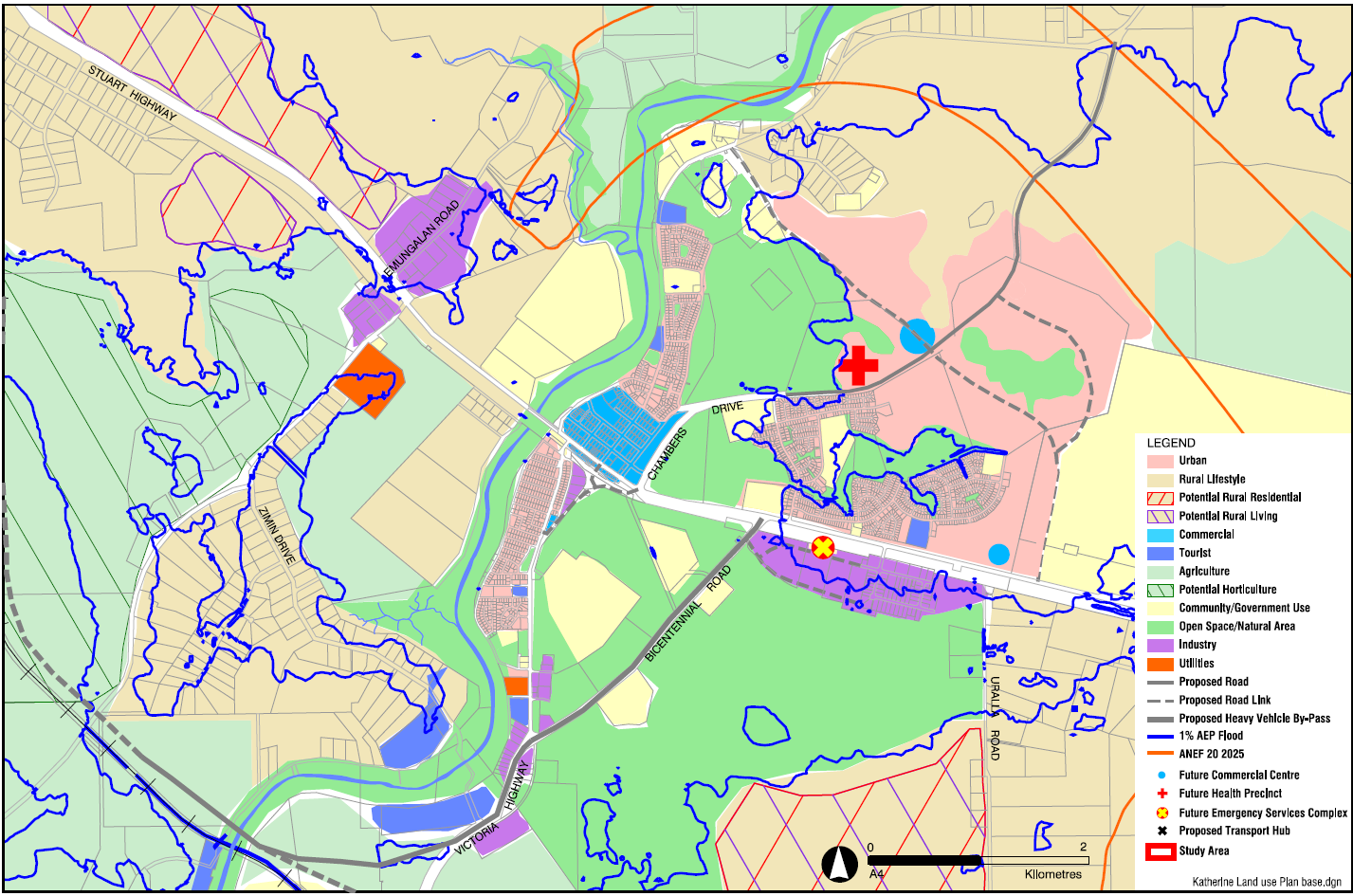
In 2015, the Katherine Region Flood Mitigation Advisory Committee commissioned an economic assessment by MacroPlan Dimasi to inform the consideration of a commercial centre outside of the flood zone. Read the Katherine Retail and Commercial Analysis Report PDF (764.2 KB).
The outcome of this report identified the immediate need for commercial and flood free land. Following this economic assessment, the Katherine Land Use Plan was amended in 2016 to include a neighbourhood commercial centre in Katherine East which provides for immediate, smaller scale flood free commercial land.
This neighbourhood commercial centre in Katherine East is off the Stuart Highway, adjacent to the Katherine Research Station.
It is proposed this site could include a full-line supermarket and speciality retail and/or household goods stores. The surrounding area could also potentially include community purpose uses, including aged care.
The Department is currently undertaking planning towards the Katherine East Residential Area Plan including the Katherine East Neighbourhood Centre.
Relocate the Katherine Ambulance Centre
The Katherine Ambulance Centre was relocated from Kintore Street, which was prone to flooding, to Chardon Street in a flood free zone and officially opened in July 2017. The new centre provides workspace for disaster management personnel as a back-up to Darwin and provides overflow disaster patient care facilities.
The Department delivered the headworks infrastructure for the new Ambulance Centre which was completed in early 2017.
Flood modelling
The flood model for the Katherine River catchment will be used to test structural flood mitigation options and their effectiveness.
Feasible options include levees which could reduce the flooding impact to properties in the smaller but more frequent flood events up to a Q20 flood, recognising that in a large Q100 flood, there is limited options available due to the extent and severity of such a flood.
Katherine River Corridor Weed Management Plan
A Katherine River Corridor Weed Management Plan has been developed in consultation with the Katherine Town Council and the Department of Environment and Natural Resources Weed Management Branch.
The plan has been created to target woody weeds, such as Neem (pictured above), within the Katherine River corridor and improve the river flow to minimise the impact of smaller flood events.
For further information, read the Katherine Weed Management Plan.
Whole of town flood resilience
A number of measures are being undertaken to improve flood awareness and resilience in the Katherine community including:
- installing lighting to illuminate the depth markers on the Katherine River so it can be read and monitored all the time
- installing an emergency generator and an 800-litre fuel tank at the Katherine Town Council depot and at Fleet Yard
- installing three permanent electronic message boards at Kintore Street, McKeddie Road and Chambers Drive to provide key messages and advice for preparing for flooding
- constructing an emergency helicopter landing pad in Katherine East that can cater for landings during the day and night as well as for large aircraft from Australian Defence Force and Careflight
- upgrade Gorge Road hardstand as a parking area for nearby residents who live in low lying areas
- installing a camera at Nitmiluk Gorge Gauging Station and replacing the camera on Katherine High Level Bridge to provide real time monitoring of water levels on the Katherine River.
- installing rising water alarms at bridges and rivers that are known to flood to alert emergency services to close access and notify the public
- upgrading the Emergency Operations Centre in Katherine Police Station
- updating flood brochures on what to do in the event of a flood.
Give feedback about this page.
Share this page:
URL copied!